Trees, flora and fauna tell part of this woodland's story. But there are always the ghostly hints of people, their actions and decisions for us to uncover.
The first question is – "why here and why this size"?
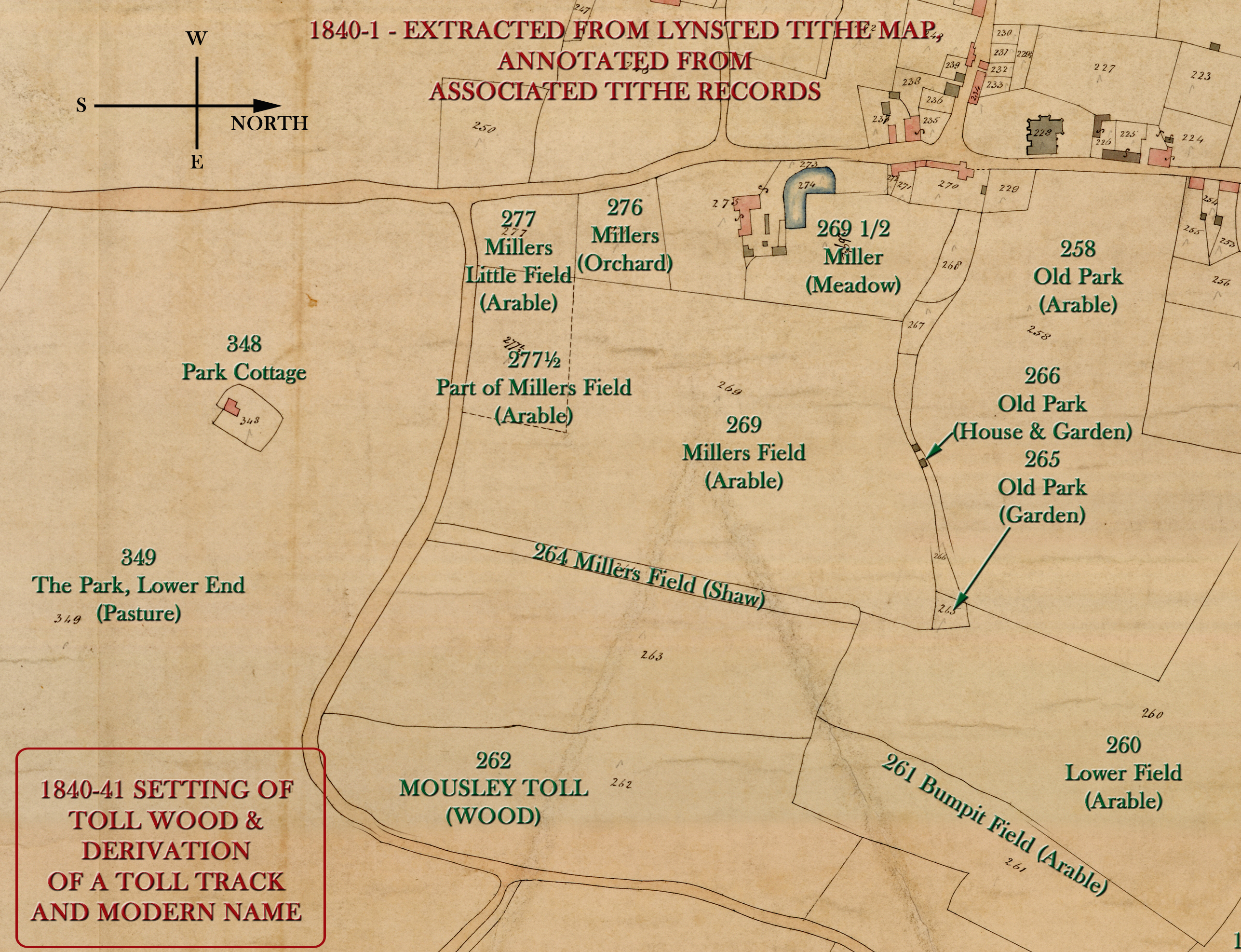
Expert author, Oliver Rackham, argues that countryside features remain unchanged for centuries if their original purpose is unchanged. That applies to lanes, hedges, ponds, woodlands, and fields. "Shocks" that change those features include enclosure, motorways, railways, disease or development. Records confirm Toll Wood as a "sporting wood" - providing cover for breeding game birds and animals, destined to be eaten. That explains the modest footprint and chaotic mix of trees found in the wood. There is no evidence of organised, continuous single-species coppicing, felling for timber or hard-fruit orchards. This wood was part of the Roper family estate into antiquity, predating Lynsted Lodge that was built to replace Bedmangore.
The Toll. An arrow-straight track once ran through the wood. Connecting the mediaeval Bumpit to the north with the wider Lynsted Park Estate held by the Lords Teynham. Bumpit was part of that estate. "Lynsted Toll Gate" is frequently quoted as a 'meeting point' for the local hunt. So, you might be forgiven for thinking this was a 'tolled' lane.
Early Ordnance Survey maps confirm the track which has now been absorbed back into the woodland. In the 1840-1841 Tithe documents, the woodland is described as "Mousley Toll Wood". In Old English - mūs 'mouse' + lēah 'woodland clearing'. This suggests the importance of the partially enclosed chalkland meadow that is part of the ancient woodland.
In 1872, the relevance of the "Mousley Toll Wood Road" was disputed by Captain Vallance (who built and lived in Aymers). In a 'secretive' Vestry Meeting he sought a "Stopping Order" to close the track through Toll Wood. Local inhabitants opposed him, arguing the importance as part of a direct connection from Newnham and Doddington to Teynham Railway Station and Greenstreet. Captain Vallance appeared to be 'unpopular' - his obituary can also be read that way - "Although not intimately known to many people outside of his social circle, and, perhaps, suffering in popular estimation from this cause, he was to those who knew him well of an urbane disposition."[22nd November 1902, EKG].
Following a meeting of the Faversham District Highways Board, on 22nd January 1872, the County Surveyor was directed to visited the road. Captain Vallance withdrew his plans, but he went on to fence off (enclose) the woodland from the lane, providing that the farm track (today's Toll Lane) was protected.So, wearing a modern hat, was "Toll" a reference to a formal extension of the Chatham to Canterbury Turnpike (as happened at Macknade)? No.
The 1888 Dictionary of Kentish Dialect gives us the most likely origin, based in the lane's historic character. A very rural track with mature trees along its edges and a small sporting woodland alongside it."TOLL [toal] sb. A clump; a row; generally applied to trees; so a rook-toll, is a rookery.
"There was a toll of trees at Knowlton which was blown down in the great November gale.""Fences/Posts. Parallel to, but set back from the Toll, are a series of oddly wedge-shaped posts with large cut-nails in some of them - see image at the top of this page. Others have iron hinge pinions. On the face of it, this suggests a period of deliberate separation between the wood, travellers and game. Elsewhere, there are several conventional wood and iron posts without obvious pattern. At times, in living memory, cattle were grazed along the edge of Toll Lane.
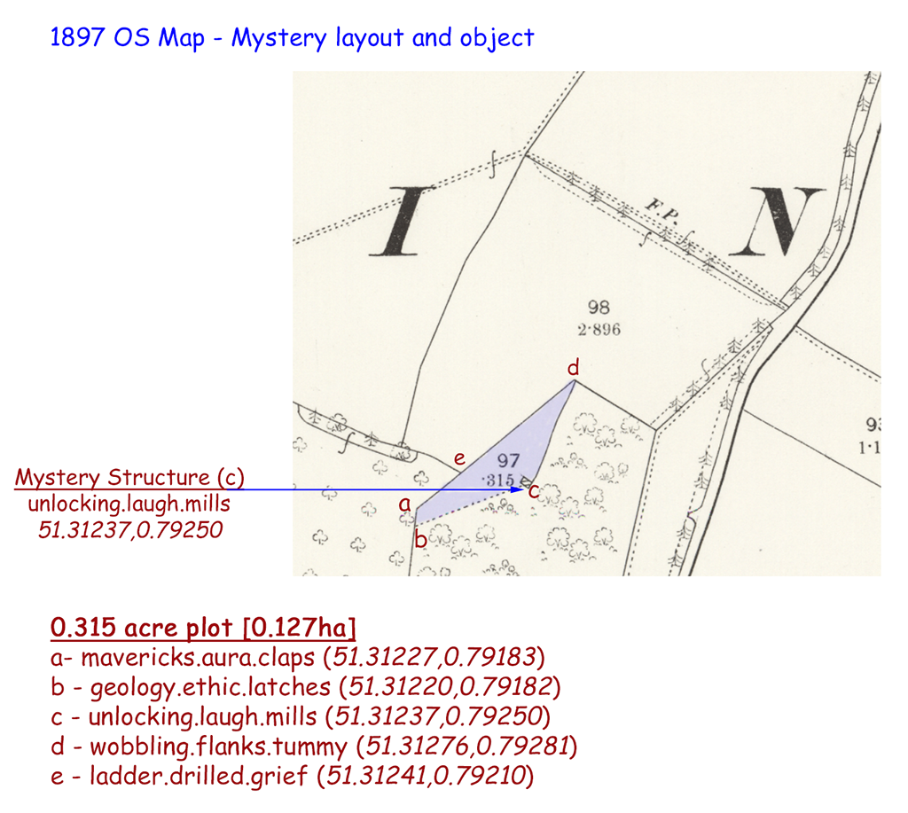
Structures. In the 1897 Ordnance Survey map (click map - right), a small man-made structure is indicated in the northern part of the wood with its own plot of land marked out! By 1906, the structure no longer appears. We have also found the remains of a structure (cement floor and bricks) that needs further investigation. Might this have been a shed for feed and traps for game?
Dene Holes. So far, we have identified a potential dene-hole in the northern section of Toll Wood. The cover/in-filling is showing signs of near-collapse. LIDAR (Light Detection and Ranging) images suggest another potential dene-hole or other manmade feature even closer to the meadow enclosure. This too needs further investigation. A close inspection of that area has failed to confirm a structure. (December 2023)
Secret Army. Toll Wood once contained a World War Two "scallywag bunker". Local adults, who knew the bunker as children, confirm that the bunker may have collapsed through storm damage (15th/16th October 1987?). There are several uprooted trees in the area. Heavy-gauge corrugated sheets (probably from an adapted Anderson shelter) are scattered near the chalk scarp. This was probably done to render the degraded site safe from prying children!?
Had Germany invaded, there was a ‘secret army’ of highly trained and fully armed local men with intimate local knowledge and skill with guns. The "scallywags" were ofetn farmers, haulage owners, gamekeepers, and poachers, their role was to mount guerrilla attacks on German forces after they passed through. Their task was to attack strategic targets. For example, ammunition dumps, senior German officers, collaborators, and senior local British figures (police and mayors) who might have known about the "scallywags". These bunkers could be made from buried corrugated iron, brick or concrete - or a mix. Fred Baker, of Ferrell and Baker Haulage Contractors on the London Road, was known to be a member of the Lynsted Patrol. Their expected life-span was around 12-days! This Secret Army was not part of the Home Guard.
The Lynsted with Kingsdown Society have recorded local reports on the Patrol as part of their World War 2 research. Researcher, Jim Gascoyne, whose father was one of the Lynsted Patrol, has directed us to the collapsed archaeological site [fn1]. The Lynsted Patrol Members are remembered in an excellent web-site (Staybehinds.com). The family names will be familiar locally - Parsons, Baker, Duncan, Eames, Gascoyne, Lloyd, Nicholls, Packham, and Whittle. A YouTube film provides good background to these bunkers. An excellent book that mentions the Lynsted's Patrol - "Britain's Secret Defences" - Andrew Chatterton.
Banks and earthworks. A chalk scarp runs north to south near the western edge of the wood where the land falls away to the neighbouring pasture. But in the southern part of the wood, there is a 'bund' creating a sunken 'dell' - carpets of snowdrops and clumps of winter aconite are found here. It is thought this 'bund' is evidence of a recent owner dumping building waste. There is a mysterious semi-circular raised earthwork set back from the scarp, only visible in winter. More investigation is needed.
Footnotes
1. "Thank you for your interest in the 'staybehinds'. I am a member of CART, the Coleshill Auxiliary Research Team and am currently listed on the website as a researcher in Kent. My father G.A.C (Clive) Gascoyne was a member of the Lynsted patrol. The Lynsted operating base (OB) was dug into a chalk bank which has collapsed over the years. I was taken there by local people who had played there as children. I hope this information helps your work. Jim Gascoyne (28th February 2023)"