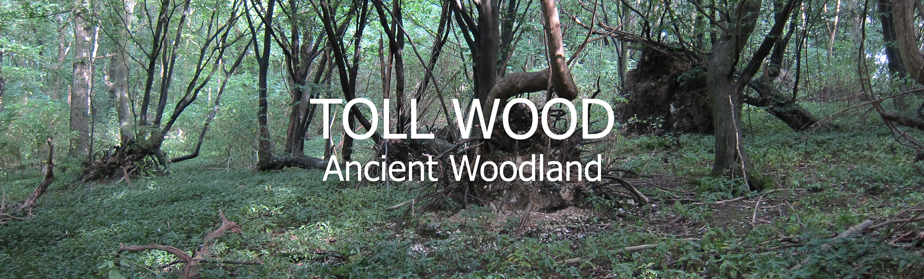
History and Setting of Toll Wood
We included the "History and Setting" of Toll Wood in our ten-year Woodland Management Plan as Appendix 1 (PDF). The size and shape of Toll Wood (sometimes called Mously/Mousely Toll) has remained almost completely unchanged for more than four-hundred years - this is confirmed by the Ancient Woodland Inventory (AWI). The encompassed chalkland meadow at the northern end is also part of that AWI footprint. "The Toll" refers to what we now know as Toll Lane. The 1888 Dictionary of Kentish Dialect reveals that "toll" is "a clump; a row; generally applied to trees; so a rook-toll, is a rookery. Early maps show trees along much of the lane edge beyond Mousely (Toll) Wood. "The Toll" was the name used habitually by those living locally into the last century.
Old auction records refer to Toll Wood as a "sporting woodland" (deer and pheasant being regularly hunted on local estates into the 20th century). The woodland size (9-acres) and topography (on the western flank of the Lyn Valley) support that description - distinguishing it from a "timber" felling wood or orchard.
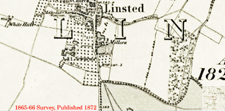
Ordnance Survey maps since the first one in 1801 (left) confirm Toll Wood in its present place. The 1801 map is much more 'impressionistic' than later maps. The later OS map (surveyed in 1854/5) and more recent surveys reveal the importance of hard-fruit orchards and parkland mixed with grazing pastures along the length of the Lyn Valley. The great depth of brickearth clay that covers the lower profile of the Lyn Valley was recently confirmed by the excavation of a V2 rocket impact and ejector zone roughly 55 metres from the north-west point of Toll Wood.
Continuity of Ownership.
Mousely Toll (sic) appears in the Linstead (sic) Tithe award schedule – signed 25th March 1840. Linstead Lodge Estate was owned by Charles Henry Tyler (Lord Teynham) - 'in his own occupation'. "Mousely Toll" was described as a "Wood" rather than than "coppice", "plantation" or "orchard". Ownership of Toll Wood lay with the descendants of the Roper/Lord Teynham owned the Wood until early 20th Century.
The 1st Lord Teynham was John Roper, b.1534, d.1618. The woodland almost certainly predates his ennoblement. The Roper family earlier lived in the ancient manor house of Bedmangore. It is unclear where Bedmangore was. Some references suggest a location near the entrance to present-day Lynsted Lodge, off Tickham Lane. Bedmangore Manor was demolished to make way for the new Roper seat at Lynsted Lodge (Logge) built in 1599. Maidstone History Centre has the Estate Papers for Bedmangore and Lynsted Lodge Estates. We have not seen those records yet (2024).
The direct hereditary line to the title of Lord Teynham was first granted in 1616. But, in 1724 with the suicide of Edward Roper, aged 20, at Almanza in Spain the direct hereditary line ended. The title and estate continued through wider familial succession into the 20th Century. The Roper family vault is attached to the nearby Lynsted Church of Saints Peter and Paul.
Changes of ownership.
Toll Wood emerged in the 19th century as part of the Aymers estate, associated with the Vallance Family for many years. Aymers was built in the 1860s, set back from The Street. It replaced the mediaeval "Millers", that used to sit next to The Street. "Millers" was earlier associated with Lords Teynham. Since then, changes in ownership of the Aymers estate, led to Toll Wood separating from Aymers.
Defining the extent of Ancient Woodland
Hidden from the public footpath (locally known as Granny Stile's Path) sits a chalkland meadow. This meadow has been grazed by cattle within recent memory. The chalkland meadow has been neglected for decades. So, we plan remedial management to stimulate chalk meadowland plants, invertebrates, and insects. Meadow management will need a different treatment to that of the woodland. The screen of mature trees at the boundary form some of the ancient woodland footprint. At the margin of the meadow are a couple of Black walnuts (the only non-native tree in the whole plot). A couple of historic dead elm sit in the meadow and will be removed as a priority.
The Ancient Woodland
The Ancient Woodland Inventory suggests a woodland area of 3.46 Hectares (8.55 acres) - there is no reason to question this. However, we have adopted the measurements held by the Rural Payments Agency for 3.74 Ha (9.24 acres) Woodland and 0.68 Ha (1.68 acres) Permanent Grassland.
Permanent Grassland
There is an odd, long and thin apron along the west margin of Toll Wood. Today, it sits under power lines, which may explain scrub and shrubs found there. There is an established thicket of spindle where this plot meets the woodland. This confirms the biological connection with ancient Toll Wood. Until 2024, UK Power Networks has felled saplings beneath the power lines. In future, the Trust will control trees in that apron to avoid the use of heavy machinery. There is an opportunity to add shrubs for pollinators, fruit, seeds and nuts.
The most significant, veteran maidens on view sit in the adjacent parkland.
The ancient parkland trees confirm the shape and mixed use of the Lyn Valley for more than six hundred years.
REMARKABLE PARKLAND TREES ADJACENT TO TOLL WOOD
Circumference (Girth) Diameter Estimated age (years) Mitchell (1974) – “Veteran” Trees (diameter) “Heritage” Class = girth greater than: Sweet Chestnut (Castanea sativa) 690cm (circ. 220cm 320-470 years 199cm dia = Truly ancient (max 318cm) 510cm dia Pedunculate Oak
(Quercus robur)515cm 164cm 274 – 300 years 150 = valuable {199cm = Truly ancient} (max 318) 454cm dia Copper Beech
(Fagus sylvatica f. purpurea)520cm 166cm 210 - 260 years 123cm dia = Truly ancient (max 197cm) 321cm dia Pedunculate Oak (Quercus robur) 670cm 213cm 500 - 600 years 199cm dia = Truly ancient (max 318cm) 454cm dia HOW OFFICIAL INSTITUTIONS VIEW TOLL WOOD
Forestry Commission - Priority Habitat; Ancient Woodland; Wider area is at potential risk from deer (Fallow and Mountjac);
Targeting and Scoring:
- Countryside Stewardship (CS) HT Biodiversity - Woodland Improvement (High Spatial Priority)
- CS HT Biodiversity - Priority Habitat Proximity - Ancient & Semi-Natural Woodland
- CS HT Biodiversity - Priority Habitat Network - High Spatial Priority (defines a protective apron (70-100m around Toll Wood)
- CS Woodland Creation and Maintenance (WCM) Biodiversity - Priority Habitat Network - High Spatial Priority (defines a protective apron (70-100m around Toll Wood)
- England Woodland Creation Offer - Priority Habitat Network [inc. grants for nature recovery; close to settlements]